


Stevenson 6 + variante

Chabard
Gebruiker
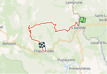

Lengte
24 km

Max. hoogte
1502 m

Positief hoogteverschil
631 m
Km-Effort
32 km

Min. hoogte
1018 m

Negatief hoogteverschil
477 m
Boucle
Neen
Datum van aanmaak :
2025-07-01 07:10:13.0
Laatste wijziging :
2025-07-01 14:28:01.84
7h16
Moeilijkheid : Moeilijk

Gratisgps-wandelapplicatie
 SityTrail
IGN / Geografische instituten
SityTrail Plus
De wereld gaat voor u open
Over ons
Tocht Stappen van 24 km beschikbaar op Occitanië, Lozère, La Bastide-Puylaurent. Deze tocht wordt voorgesteld door Chabard.
Beschrijving
La Bastide Puylaurent - Moure de La Gardille - Sources de l’Allier - Chasseradés
Plaatsbepaling
Land:
France
Regio :
Occitanië
Departement/Provincie :
Lozère
Gemeente :
La Bastide-Puylaurent
Locatie:
Unknown
Vertrek:(Dec)
Vertrek:(UTM)
571898 ; 4938011 (31T) N.
Opmerkingen